Geo Linking Service
The Geo Linking Service can compute so call Geo Link Objects between two candidate objects that have each a schema:GeoCoordinate. The service uses a routing service on top of Open Street Map to compute the straight line distance, as well as the distance and duration if one would walk, cycle or drive by car from one candidate geo coordinate to the other geo coordinate.
The Geo Link Objects contains basic routing information about the two linked objects. The corresponding domain specification can be found at https://semantify.it/ds/nN6zGPzdW.
Each created GeoLink object has the following structure (_namespaces are in the graphics omitted - blue indicates schema.org, red the odta namespace):
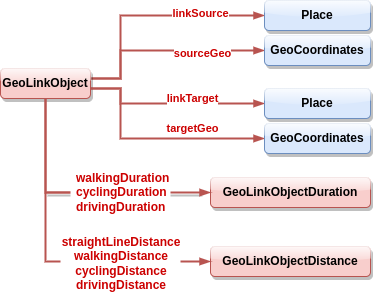
The GeoLinkObjects contains references for which source and target object and their respective geo coordinates the information about the walking | cycling | driving duration and distance was computed. Each GeoLinkObjectDistance and GeoLinkObjectDuration contain the properties schema:value, schema:unitCode and schema:unitText.
Updated 4 months ago